

Introduction
Field data collection and mapping are now essential for many industries, significantly reducing time and paperwork while enhancing efficiency and accuracy. By leveraging smartphones, tablets, and external GNSS and distance measuring equipment, organizations can gather more precise and detailed documentation. Advances in technology have introduced various applications that streamline these processes. In this blog post, we will explore some of the top field data collection and mapping applications, including Esri Field Maps, Esri Survey123, ArcGIS QuickCapture, QField, Mergin Maps, GIS Cloud – Mobile Data Collection app We’ll examine their features, technical specifications, and practical usage scenarios, showcasing how they benefit different sectors.
Esri Field Maps
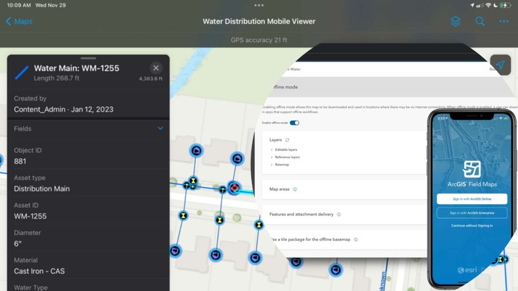
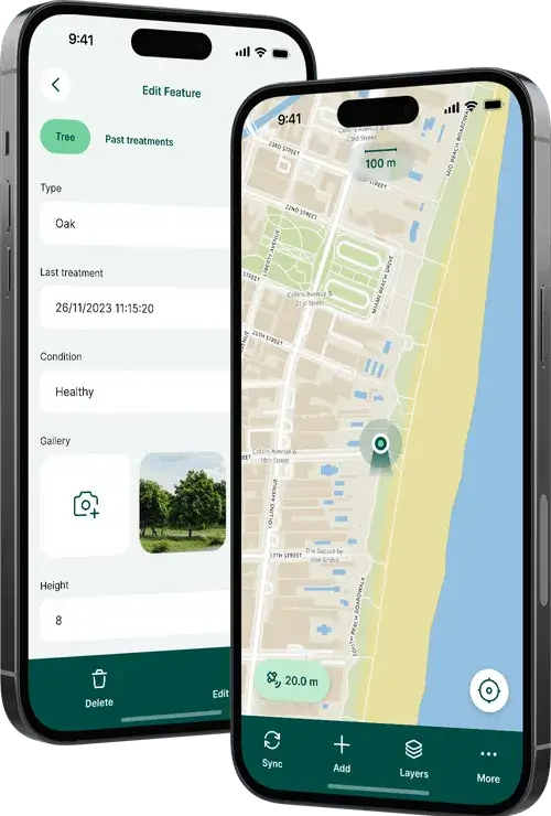
ArcGIS Field Maps is a versatile and essential app for mobile workforces, designed to enhance field data collection and mapping. It enables high-accuracy data collection, efficient inspections, and seamless offline work. Key capabilities include detailed map viewing with real-time updates, robust smart form editing, and high-accuracy data collection using external GPS devices. Users can perform inspections, collect and edit data with precision, and work with maps even without an internet connection. The app supports freehand sketching, marker placement, sharing current locations, and recording location histories.
Field Maps offers advanced symbology, layer management, and tools like GPS, basemaps, bookmarks, layers, legends, and offline map syncing. It also allows users to view and share location tracks. The app is compatible with both iOS and Android, with features like Apple Watch support, Dark Mode, and Split View on iPad enhancing its usability. ArcGIS Field Maps streamlines the process of field data collection and mapping, making it an invaluable tool for various industries.
ArcGIS Survey123
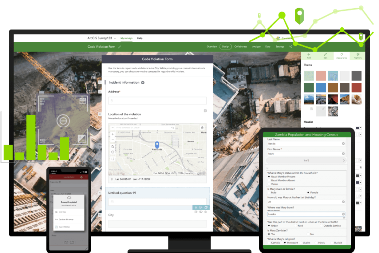
ArcGIS Survey123 is a powerful, form-centric data collection app designed to excel in gathering structured information. It’s particularly useful for detailed surveys where reporting and relational data are primary focuses. With advanced smart forms that feature conditional logic, Survey123 ensures efficient and accurate data entry every time. It supports high-precision data collection through RTK devices, meeting predefined accuracy requirements, and integrates seamlessly with ArcGIS for immediate data analysis and reporting. The app also offers offline data collection capabilities, ensuring your workflow remains uninterrupted even without internet access.
For users needing more advanced forms, Survey123 Connect is a game-changer. It allows the creation of sophisticated forms tailored to specific needs. The app supports comprehensive reporting and the use of custom templates, with export options in various formats, including Geodatabase, Shapefile, CSV, Excel, and KML. Additionally, Survey123 features an API for the Python programming language and webhooks, enabling further customization and automation of data workflows.
Survey123 is incredibly versatile, making it an excellent choice for conducting detailed surveys and inspections across various industries. It enables the high-precision data collection essential for accurate FTTx infrastructure planning and automates report generation and notifications based on survey results. This streamlines the entire data collection and reporting process, making your work more efficient and impactful.
ArcGIS QuickCapture
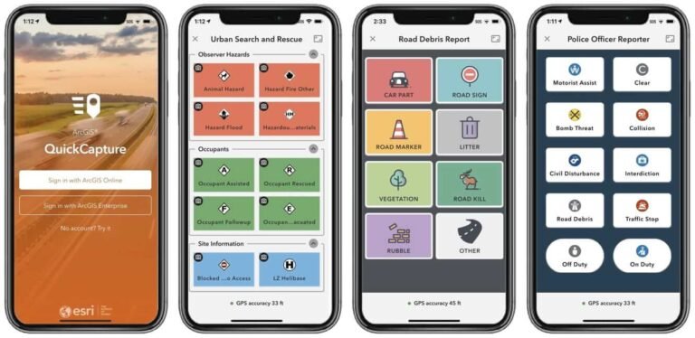
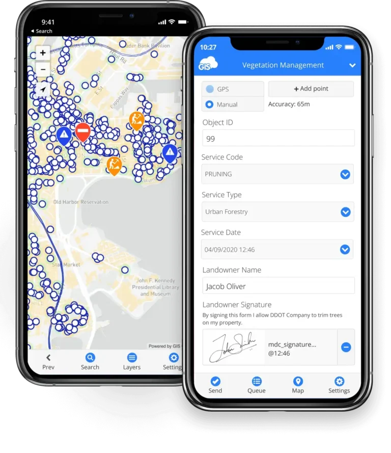
ArcGIS QuickCapture is the fastest and easiest GIS data collection app, perfect for urgent situations where rapid data collection is essential. Whether it’s reporting fires, potholes, graffiti, crime, or traffic accidents, QuickCapture enables users to collect reliable data quickly with just the tap of a button.
The app simplifies and accelerates field data capture by eliminating manual processes, saving time, and enhancing efficiency. Its user-friendly design with a big-button interface makes it easy to use, requiring minimal staff training. QuickCapture also supports offline data collection, ensuring continuous workflow even without internet access.
QuickCapture allows for easy customization using a no-code app builder. Users can create projects with customized buttons to collect locations and attributes, and deploy them instantly to field teams. The app integrates seamlessly with ArcGIS, enabling real-time collaboration and synchronization.
This versatile tool streamlines digital data collection without sacrificing quality. It enables quick documentation of features’ locations, relevant data, and photos, ensuring high productivity. With real-time data synchronization, QuickCapture provides immediate access to reliable information, helping inform decision-making and drive projects forward efficiently.
QField
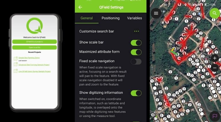
QField is a robust, open-source mobile data collection app developed by OPENGIS.ch for Android, iOS, and macOS devices. Seamlessly integrated with QGIS, QField is an excellent option for any project, from basic data collection to complex utility or construction projects with intricate forms. Its user-friendly interface ensures quick and accurate data capture with minimal training, making it an ideal tool for field teams.
One of QField’s standout features is its ability to function fully offline. Users can design detailed projects in QGIS, including forms, layers, relations, complex layer symbology and labelling, and set up constraints and data validations. These projects can be published for offline or online data collection using the QFieldSync plugin, allowing for uninterrupted data collection regardless of internet connectivity. Additionally, QField supports online synchronization with QFieldCloud, making it easy to share and update data. QFieldCloud offers both free and paid tiers, catering to occasional users as well as individuals or organizations with larger workloads.
QField’s versatility and ease of use make it suitable for a wide range of applications, from environmental surveys to infrastructure inspections. It supports various data formats and symbology, GPS positioning, and external RTK devices, ensuring comprehensive data collection. With QFieldCloud, teams can collaborate seamlessly, sharing data and updates in real-time. This integration ensures everyone has access to the most current information, enhancing efficiency and decision-making. QField transforms the field data collection process, making it faster, easier, and more reliable, and is an essential tool for anyone involved in mobile data collection. As QGIS supports Python scripting, users can automate reporting once the project is synchronized on their laptops.
Mergin Maps
Mergin Maps transforms field data collection with customizable survey forms and a user-friendly mobile interface. Users can create tailored forms in QGIS with various field types (text, numeric, date & time, QR code, etc.), group attributes for better usability, attach multiple photos, and establish table relations. Conditional visibility and validation minimize errors, while auto-calculated field values boost efficiency.
In the field, Mergin Maps excels at collecting precise vector data. Users can map assets with points, lines, and polygons, track movements in real-time, and measure areas with formulas. The optimized interface makes data collection and editing easy and accurate. Mergin Maps supports multiple coordinate systems and customizable map styles to indicate job status, assign tasks, or categorize information.
Project management in QGIS with Mergin Maps is seamless as it has dedicated plugin for data sync. Users can set up surveys using ready-made templates or custom designs, configure background layers in various formats, and create complex forms. Data versioning and history features help track changes, repair errors, and resolve conflicts, ensuring data integrity.
Mergin Maps supports high-accuracy data collection with external RTK GNSS devices, achieving up to 1cm precision. Navigation tools like stake-out mode aid in precise location tracking. Developer tools allow syncing with external databases like PostGIS, and media sync capabilities reduce mobile storage needs. Mergin Maps is ideal for industries such as agriculture, telecommunication, construction, environmental protection, water utility, natural resources, and government, offering a comprehensive solution for field data collection and management.
GIS Cloud -Mobile Data Collection
GIS Cloud Mobile Data Collection streamlines field data collection with customizable survey forms and a user-friendly mobile interface. Users can create tailored forms in a browser, incorporating various field types, grouping attributes for better usability, attaching photos, and establishing table relations. These features ensure comprehensive data collection and improve workflow efficiency.
In the field, the app excels at capturing precise vector data, allowing users to collect and inspect points, lines, and polygons, track projects in real time, and measure areas with built-in formulas. The optimized interface makes data collection and editing easy and accurate, whether online or offline. Offline collections are stored on the device and automatically synced when back online. Most users can set up surveys and train staff in less than a day due to the app’s intuitive design.
The app supports various asset types, enabling users to choose between point, line, or polygon projects for different field geometries. Data quality is ensured through options like dependencies, required fields, and radio buttons. Users can enrich their data with multimedia and capture locations using GPS or manual pinpointing, with the option to connect external GPS devices for high precision. Real-time synchronization allows for on-the-go updates across devices, enhancing team collaboration and data integrity.
Permissions can be managed to define roles such as project manager, field crew, analyst, or stakeholder. The app supports data collection, inspection, and updates using Android or iOS devices. Users can navigate to features, review and edit data attributes, and use various basemaps like Mapbox, Open Street Map, and Bing.
Summary
Field survey and mapping applications like Esri Field Maps, Esri Survey123, ArcGIS QuickCapture, QField, Mergin Maps, GIS Cloud App for Mobile data collection offer powerful tools for high-precision data collection and robust offline capabilities, making them essential for industries such as FTTx infrastructure, utility networks, and environmental mapping. These apps support accurate spatial data and integrate seamlessly with automation tools to streamline data processing, report generation, and workflows. Their user-friendly interfaces and real-time collaboration features enhance efficiency and accuracy in field operations.
At Geospatial Net, we have extensive experience in configuring, managing, and automating workflows using these applications, along with comprehensive enterprise GIS solutions. We specialize in setting up fully customized and optimized workflows to ensure efficiency and precision across various industries. Our services include writing spatial strategies, reviewing and optimizing current processes, and setting up full reporting and real-time updates between field teams and centralized data storage. Additionally, we provide custom software development and integration with other systems. Our team is always ready to assist with your projects and help you create the best workflows. Book your call today!