
A Better Way to Build Enterprise GIS
For too long, enterprise GIS has been synonymous with expensive, proprietary platforms that lock you in and limit your flexibility.
Big names like Esri ArcGIS Enterprise offer powerful capabilities—but with costs and licensing models that can be prohibitive for many organisations, especially when scaling across large teams, contractors, or municipalities.
But what if you could build a fully enterprise-grade, open source GIS platform—supporting planning, field data collection, asset management, custom automations, and rich web mapping—using proven, mature open source GIS tools for a fraction of the cost?
That’s exactly what we help telecom operators, utilities, councils, and infrastructure companies achieve.
What We Mean by ‘Enterprise-Grade’?
This isn’t some basic, lightweight open source setup.
We’re talking about a complete, production-ready GIS environment that’s designed for real-world, enterprise needs. The kind of system that can truly replace commercial platforms—not just mimic them—but with the flexibility and cost savings that come from avoiding vendor lock-in.
It’s not just a map on a screen. It’s the foundation for connected, modern workflows across planning, field operations, management, and reporting.
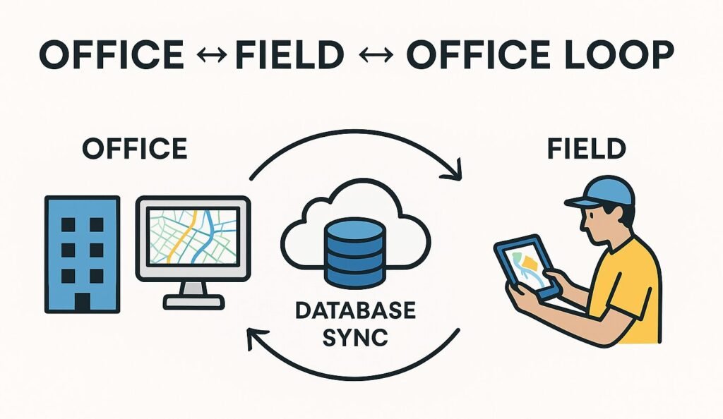
You can empower your field crews with mobile apps that work even offline, letting them capture photos, sketches, inspections, and precise geolocation data with smart, structured forms. If you need survey-grade positioning, they can even connect to external GNSS receivers for high-accuracy data. And all of it syncs back seamlessly, so nothing gets lost or buried in email attachments and spreadsheets.
Your spatial database isn’t an afterthought, either. Using PostgreSQL and PostGIS gives you robust, secure, multi-user data management designed to handle complex asset networks, maintain version history, and back up critical data reliably. And because PostgreSQL is one of the most complete, extensible database platforms available—including support for advanced data types and vector embeddings through extensions like pgvector—you’re already set up for integrating AI models, MCP frameworks, and advanced analytics down the line.
And when you need to share insights? Your team can publish professional, interactive web maps that mirror your planning environment—making it easy for contractors, managers, or even the public to get a clear, accessible view of your project.
Documents, photos, and videos are no problem. The system integrates with cloud or on-premises storage so you can keep all your project media well-organized and easy to find.
Need something specific? You can build it. With QGIS’s plugin ecosystem and open APIs, you’re free to design custom routing tools, automated reporting scripts, or integrations with CRM, ERP, or permitting systems.
This kind of setup isn’t just about replacing expensive licenses. It’s about owning your data and your workflows—so you can work smarter, move faster, and serve your customers better.
It’s an open source approach built for the real demands of telecom operators, utilities, councils, and infrastructure owners—designed to handle everything from FTTH network planning and permitting to sewer inspections and asset maintenance.
The Core Open Source Components We Build With
This isn’t about cobbling together free tools—it’s about engineering a fully integrated, production-ready GIS platform using the best open source technologies the industry has to offer.
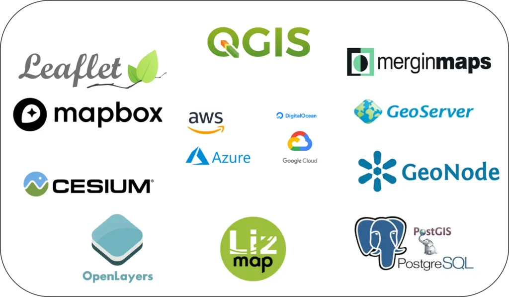
At the heart of it all is PostgreSQL + PostGIS, a proven, enterprise-grade spatial database trusted worldwide by telecoms, utilities, and governments alike. It handles everything from complex asset networks to planning layers, complete with versioning, security, and backup.
QGIS Desktop gives your planners and engineers a professional-grade environment for design, analysis, and cartography, with support for advanced forms, domain controls, and custom plugin development that fits your exact workflow.
For field operations, we deploy Mergin Maps—a platform we’re proud to be official partners with. It lets your teams collect data offline or online, complete with photos, forms, sketches, and geolocation, all syncing seamlessly back to your central database in real time.
When it’s time to share insights, you can deploy Lizmap or MapStore to turn your QGIS projects into rich, interactive web maps—making data accessible to managers, contractors, or even the public without losing the integrity of your planning environment.
And it doesn’t stop there. GeoServer provides standards-compliant OGC services (WMS, WFS), enabling integration with any client that supports those protocols. We also help connect your platform with secure document management solutions like Nextcloud, ensuring your photos, plans, and reports are safely stored and easy to find.
But true enterprise GIS isn’t just about maps—it’s about turning data into decisions. That’s why we also support integrating tools like Apache Superset for dashboards and data exploration, N8N for powerful no-code automations and workflows, or even Power BI if you need tight integration with your existing reporting environment.
And because the whole system is built on open standards and extensible APIs, you can connect it with your CRM, ERP, permitting systems, or asset registers, ensuring your GIS becomes the single source of truth across your organisation.
Why This Matters for Telecom, Utilities, and Infrastructure Owners
If you’re a telecom operator, imagine managing your entire fiber network—from planned routes and splicing plans to permits, as-builts, and field-collected photos—all in one unified system your team actually owns and controls. And because there are no per-user license costs, you can scale to as many users as you need without paying extra, ensuring everyone—from planners to field crews—has access.
For utilities, this platform supports managing water, sewer, stormwater, or electrical networks with spatially accurate asset registers, inspection histories, and live maps your field teams and contractors can rely on. You can also build as many custom tools and forms as you need, fully supported by plugins and automations designed to optimize your team’s time and boost productivity.
Councils and infrastructure managers can maintain roads, property assets, parks, and facilities with consistent, validated data, mobile inspections, and interactive dashboards—without paying for licenses you don’t need or losing control of your own data. And with open, extensible technology, you’re free to customize the system to fit exactly how you work—today and as your needs grow. Plus, you can make better decisions based on data that’s visually easy to access, thanks to custom interactive dashboards and maps that let you track costs, productivity, project progress, contractors, and more.
Proven in the Real World
These aren’t experimental ideas. These technologies are already proven, mature, and stable, with real-world deployments supporting the kinds of organisations we work with. Open source GIS solutions power everything from national cadastral systems to municipal asset registers and utility inspection workflows.
This approach is production-ready and enterprise-grade, without the costs and lock-in of proprietary vendors. And because these tools are widely adopted, there’s already a large pool of professionals trained in using them—making it easier to build skilled teams and integrate them into your operations seamlessly.
A Fraction of the Cost of Commercial Licensing
Let’s be honest: enterprise GIS from big-name vendors can cost tens to hundreds of thousands every year in licensing alone—not to mention per-user fees, training, and vendor lock-in.
With an open source approach, you get enterprise-grade capability at a fraction of the price:
- No per-user licensing fees holding back your team
- No vendor lock-in that limits your choices
- Freedom to scale as your organisation grows
- Full ownership of your data and workflows
- A large open-source community that’s constantly improving the tools, fixing bugs, and adding new features—keeping your platform robust, modern, and up to date for years to come
What Geospatial Net Delivers
We don’t just install software. We partner with you to design, deploy, and support a complete enterprise GIS platform tailored to your organisation’s needs.
Our team includes industry engineers (telecom, civil, and surveyors), data analysts, data science specialists, and software engineers who work closely with you to design your system, document every step, and ensure it truly aligns with your workflows and goals. From planning to implementation to training, we offer complete, hands-on assistance every step of the way.
- Careful planning and design of data schemas, forms, and workflows
- On-premises or cloud deployment (AWS, Azure, Hetzner, DigitalOcean)
- Secure, maintainable, and scalable infrastructure
- Custom training tailored to your team’s roles and workflows
- Full documentation to support adoption and future maintenance
- Complete migration of the legacy data
- Ongoing support and maintenance as your needs evolve
- Seamless integration with your existing systems and data sources
- Automation of QA/QC and reporting workflows to reduce errors and save time
- Development of custom forms, plugins, and analysis tools to optimise your operations
- Support for AI integration to enhance analytics, automate processes, and unlock new insights from your data
Coming Soon: Real-World Demonstration Series
Over the next few weeks on our blog, our team will be sharing practical, step-by-step demonstrations so you can see exactly how this all comes together. You’ll get a clear understanding of how to:
- Create complete, telecom-specific projects with well-designed data schemas in PostGIS
- Build QGIS projects with custom smart forms, symbology, and domain controls tailored to real-world workflows
- Implement database triggers and validation rules to ensure data quality and consistency
- Design intuitive field data collection forms for Mergin Maps that support offline and real-time collaboration
- Publish interactive web maps and portals using Lizmap and MapStore to share data with teams, contractors, or the public
- Develop dashboards and reporting tools that give decision-makers clear, actionable insights
- Integrate everything into a single, collaborative workflow—seamlessly connecting office planning, field operations, and management
Follow us on our blog and social media to stay updated and see how you can put these powerful workflows to work in your own projects.
Let’s Build Your Enterprise GIS Together
If you’re tired of overpriced, inflexible GIS systems that lock you in and slow you down, let’s talk.
We’re passionate about building GIS that actually works the way your business does—for planning, permitting, construction, operations, and maintenance.
Contact us today to learn more or schedule a free, no-obligation consultation.