
When fiber deployment projects fail, it’s rarely because of one big, obvious mistake. More often, they unravel quietly—through a slow accumulation of small missteps that go unnoticed until it’s too late. These aren’t the kind of errors that show up in bold red on a project tracker. Instead, they’re subtle, everyday issues that slip through the cracks—each one manageable on its own, but collectively powerful enough to derail the entire effort.
It’s the build-up of small, unchecked issues that causes the biggest setbacks:
A misinterpreted scope of work that leads design teams and construction crews down different paths, wasting time, materials, and resources before the mismatch is even discovered.
An unexpected site condition, such as underground obstructions or access restrictions, that was missed during early planning—and now forces crews to improvise in the field, often at a higher cost and with questionable results.
A change request that seemed minor on paper but wasn’t evaluated for its ripple effects, ultimately requiring rework, new permits, or updated documentation across multiple teams.
These kinds of issues don’t explode—they erode. And by the time they surface in project reviews or budget forecasts, the damage is already done: the schedule is slipping, the budget is blown, and the entire team is scrambling to regain control.

At Geospatial Net, we’ve supported FTTH and telecom rollouts across multiple countries and continents. We’ve seen firsthand how even the most experienced teams can get tripped up—not from lack of effort, but from the hidden complexity that creeps in as a project grows.
And through all of that, one truth stands out:
The difference between success and struggle isn’t how hard your team works—it’s how well the project is planned, how clearly everyone communicates, and how strong your systems are for managing change.
In other words, you don’t need more layers of complexity.
You need a smarter way to manage the complexity that’s already there—one that brings visibility, streamlines processes, and keeps your entire team aligned from planning through execution.
That’s where a GIS-driven approach can change the game—bringing together modern systems, methodical and practical workflows, automated processes, and connected data that feeds into real-time dashboards and analytical visualizations, giving you complete clarity and control from start to finish.
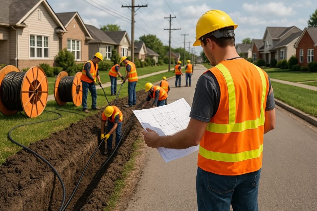
Telecom Projects Have Hundreds of Moving Parts
Analytics and investments. Design and permits. Subcontractors. Field updates. Client expectations. Construction milestones. Data collection. Reporting. Inventory. Documentation.
Every part matters—and it’s all supposed to work together.
The real challenge isn’t laying the fiber. It’s keeping every moving part aligned as you plan, build, and deliver a network that works flawlessly from day one.
That’s where we come in.

What We Help You Do (and How We Do It)
We work with telecom companies, utilities, engineering firms, construction companies, and system integrators to deliver complex projects and design enterprise GIS solutions—with full support for large-scale infrastructure deployments, network inspections, and asset management.
Our services are tailored to every phase of your network’s lifecycle—from initial planning to long-term maintenance.
Let’s break that down:
Strategic Support and Turnkey Planning
We help you build a fiber deployment strategy that aligns with your goals, constraints, and timeline.
Our team works closely with yours to:
Translate high-level ideas into actionable designs, backed by spatial analysis and real-world data
Identify risks and constraints early, such as access limitations, permit zones, and environmental or construction challenges
Deliver end-to-end FTTH planning, from high-level network architecture to detailed construction packages ready for rollout
Support field teams during construction, ensuring designs are practical, accessible, and adaptable to real-world conditions
Track and manage design changes, capturing field updates in real time and reflecting them in your system of record
Provide structured as-built documentation, created through automated processes and aligned with your internal standards and compliance requirements
Process and integrate survey data—both spatial and non-spatial—and support the administrative side of your project, including data management, version control, and documentation workflows
Optimized Planning Tools and Data Workflows
We don’t just hand over a plan — we design better ways to plan.
Our approach builds efficiency and accuracy into every step, using smart systems and proven methods to streamline complex work:
Integrated GIS and CAD workflows that balance the need for precision with the ability to scale across large geographies
Smart templates and rule-based design standards that promote consistency across teams, regions, and projects
Repeatable, modular processes that reduce time and effort per project—without sacrificing quality
Connected systems and collaborative tools that keep planners, surveyors, and managers aligned in real time, with clear roles and synchronized data

Enterprise GIS Systems — Field to Office, and Beyond
We design and deploy full-stack GIS systems—hosted in the cloud or on-premises—built to meet the complex demands of telecom, utilities, and other infrastructure-intensive industries. With Web, Desktop, and Mobile access, your entire team can stay connected and aligned, wherever they are.
With our enterprise GIS solutions, your team gets:
A single source of truth across all departments, reducing miscommunication and data duplication
Live, interactive maps showing fiber routes, assets, annotations, and metadata—updated in near real time
Field-ready tools that support smart forms, media uploads (photos, videos), GPS tracking, and live status updates
Custom dashboards and automated reports, delivering clear, consistent insights without the manual effort—fed directly from live databases, so project managers don’t have to spend time creating presentations or compiling routine updates. Everything is accessible anytime, anywhere, and always up to date.
Ongoing support throughout construction, commissioning, and long-term maintenance—ensuring the system evolves with your needs
From the first survey to final as-built documentation, everything is streamlined and connected. Every role—from designers to field crews to executives—has the visibility and tools they need to do the job right, the first time.


Why It Matters
When you’re running large-scale projects or managing multiple deployments in parallel, the cost of chaos is high.
Without the right systems and visibility in place, even small issues can snowball into serious problems:
Missed timelines that drain budgets and push back delivery
Unclear scopes that create confusion, rework, and friction between teams
Data silos that delay decisions and leave key stakeholders in the dark
Field teams that lose trust when plans constantly shift without explanation
But when your operations are well-structured—when data flows seamlessly, workflows are clear, and everyone is aligned?
Projects stay on track, even in dynamic or fast-paced environments
Margins are protected, with less waste, fewer delays, and minimal rework
Teams stay aligned and supported, whether they’re in the office or out in the field
Clients see results—and trust you as a capable, consistent partner who gets the job done
Why Clients Trust Geospatial Net?
At Geospatial Net, we bring depth where it matters most.
Our team combines strong capabilities across engineering, technology, project management, and data—with direct experience working for investors, asset managers, contractors, network operators, design consultants, and field teams.
We’ve been part of planning meetings, walked construction sites, and navigated the real-world challenges of tight deadlines, shifting scopes, and complex coordination. That’s why our solutions are practical, scalable, and built for the realities of large, multi-stakeholder projects.
We focus on what actually moves projects forward:
✔️ Turnkey FTTH and utility network planning, from concept to construction
✔️ Enterprise-grade GIS systems for Web, Desktop, and Mobile—tailored to your operations
✔️ Optimized GIS and CAD workflows that bring precision, speed, and consistency to design and documentation
✔️ Smart field data collection tools, integrated directly into planning, execution, and reporting
✔️ Automated dashboards and full asset inventories, providing real-time clarity from strategic to field-level views
✔️ Responsive, reliable support—whether you’re launching a new rollout or adjusting mid-build
Let’s Make Your Next Project Easier
You don’t have to keep working around chaos, broken scopes, and fragmented systems.
Let’s talk about how we can help you streamline planning, unify your data, and support your team from start to finish—across the entire lifecycle of your network or infrastructure project.
Free consultations. No pressure. Just real advice.
📧 contact@geospatialnetworks.com
We’re people first—and we’re here to make your job easier, your projects smoother, and your results stronger.